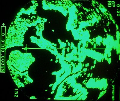
When driving the tugboats through the bayous, bays and backwaters of South Louisiana, we always run our radar. The radar 'sweeps' the surrounding area with radar waves and watches them return. It then displays the solid targets it finds in green and the water stays black.
This gives us a kind of moving map. It's very useful even in broad daylight to show us our surroundings and is sorta our rear-view mirror. With a lil practice ya can tell where ya are by the image on the radar. It picks up bouys and shows ya a channel across a bay. Ya see boats moving about and can even see flocks of ducks when they fly bunched together. It takes a lil practice to use and tune the radar, so boat captains are trained by the Coast Guard to do so. Not only did I receive an indepth week-long training course ( only after using the radar for several yrs. as an apprentice) but we are also re-tested by the Coast Guard every 5 yrs. to prove familiarity and competence. In the bays and unmarked routes we travel, we navigate by radar alot. Radar images become familiar and many navigation "land marks" have been given names based on their radar image. I've included one of the more obvious examples of these land marks. Its kinda like looking for images in clouds, but I'm sure ya will see why this area is called Sea Horse Bay.
No comments:
Post a Comment